Heidelberg Maps and Orientation
(Heidelberg, Baden-Württemberg, Germany)
Heidelberg is located just under 130 km / 81 miles to the north-west of Stuttgart and is also extremely close to Mannheim, which lies to the west, and
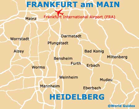
Frankfurt, to the north. Famous for its university, which is the oldest in the whole of Germany, the city of Heidelberg features an appealing backdrop of mountainous scenery and has been built around the Neckar River.
Located within the state of Baden-Württemberg, Heidelberg is a city of many faces. The western side of Heidelberg is fairly modern and begins around the Hauptbahnhof train station. For more history and a glimpse into the past, the true romance of the old city begins to reveal itself around Bismarckplatz, sited close to the Kurfürstenanlage. Nearby, the Hauptstrasse is an important pedestrianised thoroughfare and leads to many places of interest.
Maps and Orientation of the City
Within the city there are two main bridges which span the Neckar River, standing on the northern side of the Bismarckplatz area and also to the north of Heidelberg Markt district. Outside of central Heidelberg, various places of interest are just a short drive away, with a range of attractions situated within the following nearby cities and towns.
- Bretten - 56 km / 35 miles (50 minutes, south)
- Bruchsal - 40 km / 25 miles (40 minutes, south)
- Darmstadt - 59 km / 37 miles (50 minutes, north)
- Frankfurt Am Main - 88 km / 55 miles (one hour and 20 minutes, north)
- Heppenheim - 61 km / 38 miles (50 minutes, north-west)
- Leimen - 8 km / 5 miles (10 minutes, south)
- Ludwigshafen Am Rhein - 22 km / 14 miles (25 minutes, north-west)
- Mainz - 93 km / 58 miles (one hour and 25 minutes, north-west)
- Mannheim - 21 km / 13 miles (20 minutes, west)
- Mosbach - 40 km / 25 miles (40 minutes, east)
- Pfungstadt - 51 km / 32 miles (45 minutes, north)
- Sinsheim - 40 km / 25 miles (40 minutes, south-east)
- Speyer - 45 km / 28 miles (45 minutes, south-west)
- Stuttgart - 128 km / 80 miles (one hour and 40 minutes, south-east)
- Wiesloch - 18 km / 11 miles (20 minutes, south)
Map of Germany

Map of Heidelberg